Laguna Seca map
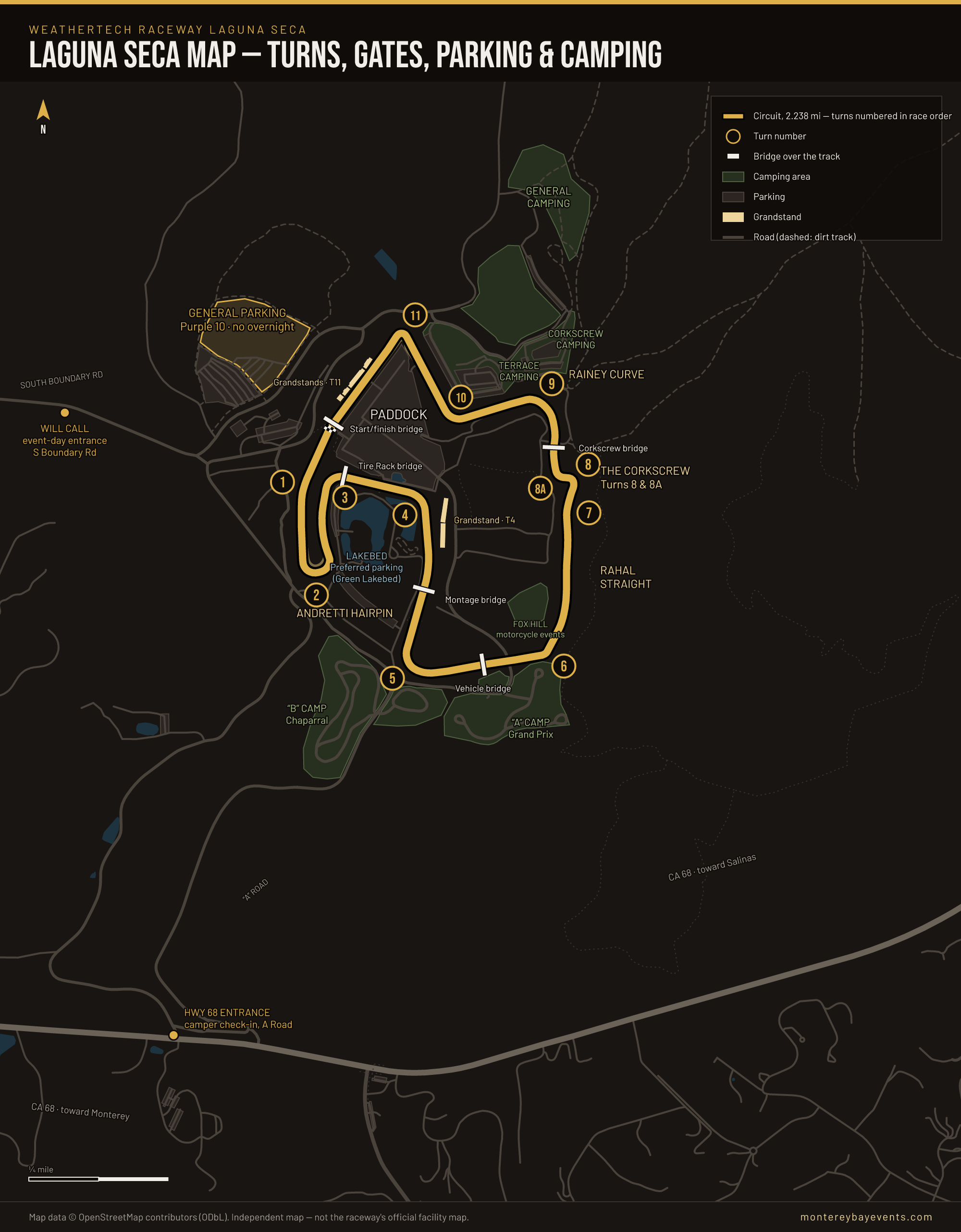
WeatherTech Raceway Laguna Seca is a 2.238-mile, eleven-turn circuit in the hills off Highway 68 between Monterey and Salinas. On major event days you come in from South Boundary Road, on the west side, where Will Call is; General Parking (the Purple 10 lot) is right there, and the circuit, paddock and grandstands are a short walk east. The grandstands are at Turns 4 and 11, and general admission can also sit on the hillsides at the Andretti Hairpin and the Corkscrew. Campers come in the other way, from Highway 68 up A Road.
How to read this map
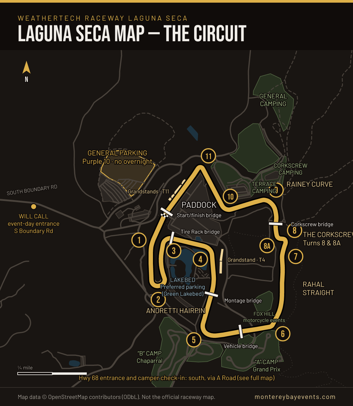
- North is at the top. The raceway's own facility map puts north on the left, so everything on it is turned a quarter-turn from ours. Its “Main Entrance” at the bottom of the page is the South Boundary Road gate on the left of this one.
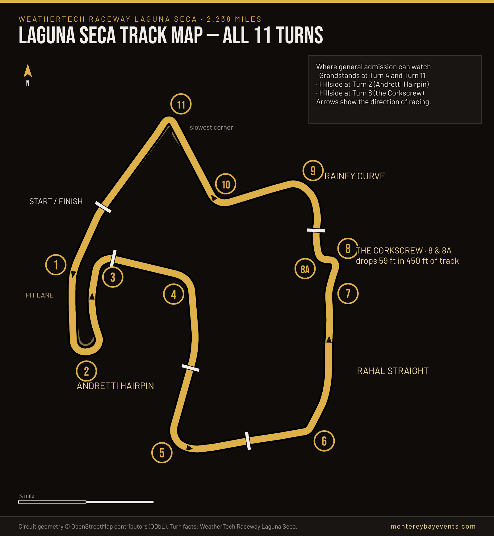
- Turns are numbered in race order. Follow 1 to 11 and you have done a lap. The direction of racing is marked on the track-only diagram below.
- White bars are bridges over the track — the only way across the circuit while cars are running. There are five: start/finish (Mission Foods), Tire Rack, Montage, a vehicle bridge before Turn 6, and the Corkscrew bridge.
- Green areas are campgrounds, dark grey is parking, pale gold bars are grandstands. The large outlined lot on the left is General Parking.
- Everything is drawn from OpenStreetMap, not traced from the raceway's map. The lap on our drawing measures 2.237 miles against the published 2.238, so positions are true to the ground — but the raceway notes that facility locations and access routes vary by event, and its map for your event wins.
Turn by turn
What each corner is and what sits next to it on the map. Corner descriptions are from the raceway's Racing Lines flyer, the Corkscrew figures from its track information page.
- 1
Turn 1
A blind corner taken at full speed, just past the start/finish bridge at the end of the front straight.
On the map: The start/finish (Mission Foods) bridge, just before it; the raceway's own map puts its Hospitality Pavilion on the outside.
- 2
Turn 2 · Andretti Hairpin
The long hairpin at the bottom of the front straight. The raceway's flyer calls it mostly a single-apex corner, entered from the right after braking.
On the map: Hillside viewing, one of the four places the raceway names for general admission.
- 3
Turn 3
The first of the infield corners added in 1988, which took the lap from 1.9 to 2.238 miles. The apex comes late.
On the map: Tire Rack foot bridge, just after the turn.
- 4
Turn 4
A fast, unbanked corner — the flyer warns cars often slide at the exit.
On the map: Uncovered grandstand on the outside, first come, first served.
- 5
Turn 5
The track starts to climb at the apex; the slight banking begins mid-corner.
On the map: Montage foot bridge on the approach; B Camp (Chaparral) to the south.
- 6
Turn 6
A dip into the apex that can unsettle a car; the flyer has drivers start braking at the bridge.
On the map: Vehicle bridge on the approach; A Camp (Grand Prix) beside it.
- —
Rahal Straight
The straight from Turn 6 to Turn 7, up the east side of the circuit.
On the map: Fox Hill (motorcycle-event camping) on the inside.
- 7
Turn 7
Turn-in comes just before a blind crest; the car has to be lined up on the right for the Corkscrew.
- 8 / 8A
Turn 8 / 8A · The Corkscrew
Hard left, hard right, downhill and blind. A 12% drop at the apex of 8 and 18% at 8A — 59 feet of fall in 450 feet of track, and 109 feet from Turn 8 to Turn 9.
On the map: Corkscrew hillside viewing; Corkscrew and Terrace campgrounds above; the Corkscrew foot bridge just after 8A.
- 9
Turn 9 · Rainey Curve
A fast downhill sweeper, blind on entry.
On the map: General Camping and the Terrace campgrounds to the north.
- 10
Turn 10
Drops into a bowl and picks up speed quickly; braking is harder than it looks.
On the map: Paddock on the inside.
- 11
Turn 11
The slowest corner on the track — slow in, fast out onto the front straight.
On the map: Uncovered grandstands along the front straight, with the pit lane running beside it.
Laguna Seca track map with turn numbers
The circuit on its own, bigger, with arrows for the direction of racing. This is the one to keep on a phone if you are following a race from the hillside and want to know which corner the commentators mean.
Getting in: two entrances, used for different things
South Boundary Road (west) — spectators on event days. The raceway's ticket page says that for its major 2026 events “you must come in through the South Boundary Rd. entrance to the park.” Will Call is on the right as you enter, open from 7 a.m. until halfway through the last race of the day. The raceway's directions page gives the event-day address as S Boundary Rd, Monterey, CA 93940 — use that, not the street address, in a map app on race day.
Highway 68 (south) — campers, and non-event days. The non-event address is 1021 Monterey-Salinas Highway, Salinas, CA 93908. The raceway's event camping rules put camping check-in “at the bottom of A-Road off of HWY 68 (main entrance)” — the marked point at the bottom of our map. Check-in runs 2:00 to 5:00 p.m.
The two documents call different gates “main entrance”: the camping rules mean Highway 68, the facility map means South Boundary Road. They are not contradicting each other so much as writing for different visitors. If you are camping, Highway 68; if you are not, South Boundary.
Gates generally open at 7 a.m. on race days and close at 10 p.m. or midnight depending on the event. Monterey Regional Airport is 7 miles away by the raceway's count; San Jose International is 75. For road conditions on the Peninsula, see our traffic and closures guide.
Parking: Purple 10 or the Lakebed
- General Parking — Purple 10. The big lot west of the circuit, off South Boundary Road. On our map its middle is about 0.3 miles in a straight line from the paddock and 0.6 miles from the Corkscrew.
- Preferred Parking — Green Lakebed. Inside the circuit, around the lakebed between Turns 2, 3 and 4. Sold separately; you are parking inside the infield.
- No overnight parking in either. A vehicle left overnight needs a camping pass for a designated campground.
- What is not published: a price for General Parking, ADA parking locations, and any shuttle or tram between lots. Ask the ticket office on (831) 242-8200 before you plan around any of them.
Where to watch with a general admission ticket
General admission gets you into the track and the paddock — the “cold garage” area where teams set up, not the hot pits. From there the raceway names four places to watch:
- Turn 11 grandstands — uncovered, first come, first served, along the front straight. The closest of the four to General Parking: about 0.3 miles in a straight line on the map.
- Turn 4 grandstand — beside the paddock, inside the circuit, so you cross the track on a bridge to reach it; about 0.4 miles.
- Turn 2 hillside — the Andretti Hairpin at the bottom of the front straight; about 0.4 miles.
- Turn 8 hillside — the Corkscrew, on the far side of the circuit and also across the track; about 0.6 miles, the farthest of the four.
You can bring blankets, umbrellas and folding chairs for the hillsides, and small ice chests; leave glass at home. Children 15 and under get in free with a paid adult. Hospitality clubs vary by event — at the 2026 INDYCAR finale the Turn 3 VIP Club overlooked the Andretti Hairpin and Turns 3 and 4.
The campgrounds on the map
The raceway says it runs event camping in six locations around the track, in three tiers. Where they sit on the map:
- North of the circuit, by Turns 9–11: General Camping (dry, first come, first served), and the Corkscrew and Terrace campgrounds above the Corkscrew and Rainey Curve.
- South, by Turns 5–6: A Camp (Grand Prix campground) and B Camp (Chaparral), closest to the Highway 68 entrance.
- Inside the circuit, east: Fox Hill, which the raceway's event camping guide marks as motorcycle events only.
Two smaller camping areas south of the track are mapped in OpenStreetMap but not labelled on ours, because we could not match their OpenStreetMap names to the raceway's. For tiers, the 40-foot RV limit, the six-adult cap, booking and what nobody publishes about prices, see our full Laguna Seca camping guide.
Three ways people get this wrong
Routing to the street address on race day
Typing “1021 Monterey-Salinas Highway” sends you to the Highway 68 gate at the bottom of the map. On a major event day that is the camper entrance; spectators were told to use South Boundary Road, on the opposite side of the property — about 1.1 miles apart in a straight line on the map, and further by road. Navigate to “Will-Call Laguna Seca Raceway, S Boundary Rd” instead.
Arriving at the campground after 5 p.m.
Camping check-in is 2:00 to 5:00 p.m., at the bottom of A Road. A pass bought for the Grand Prix campground does not change that window, and General or Preferred parking will not take the car overnight. If you will be late, call (831) 242-8200 before you leave rather than after you arrive.
Planning on “a quick walk to the Corkscrew”
From the middle of General Parking the Corkscrew is about 0.6 miles in a straight line, across the circuit, and you can only cross at a bridge. Nobody publishes a walking route or time for it, and the hill is steep — the track drops 109 feet between Turns 8 and 9 alone. If the Corkscrew is the reason you are going, go there first and stay.
What this map does not show, and why
- Restrooms, food and first aid. They move by event and the raceway's own map is the place for them; we would rather not pin a restroom that was somewhere else last weekend.
- Walking routes and times. Not published by anyone.
- ADA parking and accessible routes. The raceway publishes ADA access for its Pavilion rooftop and marks accessible campsites, but no ADA parking area. Ask on (831) 242-8200.
- Shuttles and trams. None published.
- Event-specific hospitality. Clubs, suites and pavilions change from event to event.
For all of those, the raceway's official facility map (linked from its track information page) is the authority. Map data on ours © OpenStreetMap contributors, ODbL.
Questions
Where do I park at Laguna Seca?
General Parking is the Purple 10 area, reached from the South Boundary Road entrance — the large lot west of the circuit on our map. Preferred Parking, which you buy separately, is in the Green Lakebed area inside the infield. Neither allows overnight parking; leaving a vehicle overnight needs a camping pass. The raceway publishes no price for General Parking.
Which entrance should I use?
For the raceway's major 2026 events it said you must enter through the South Boundary Road entrance, with Will Call on the right from 7 a.m. On non-event days the address is 1021 Monterey-Salinas Highway, and campers check in at the bottom of A Road off Highway 68.
How long is Laguna Seca, and how many turns does it have?
2.238 miles, with eleven numbered turns plus 8A — the Corkscrew is officially Turns 8 and 8A. The lap measured from the OpenStreetMap geometry behind our map comes to 2.237 miles, which is how close the drawing is to the real track.
Where is the Corkscrew on the map?
On the east side of the circuit, at the top of the climb from Turn 6. It is the far side of the track from General Parking — about 0.6 miles in a straight line from the middle of the Purple 10 lot, measured on the map, and more on foot. Spectators can sit on the hillside by Turn 8.
Can I bring chairs or a cooler?
The raceway's ticket page allows blankets, umbrellas and folding chairs on the hillsides, and small ice chests. It asks you not to bring glass. It publishes no bag-size rule.
Is there an official Laguna Seca map?
Yes. The raceway publishes a facility map on its track-information page, drawn with north to the left. Ours is drawn with north at the top from OpenStreetMap data, so if you compare the two, rotate one of them a quarter-turn.